

10 Best Location Intelligence Software
Location intelligence software is a business intelligence solution that provides location analytics to identify the relationship between certain objects based on their physical locations.

But what is the right location intelligence software for your company?
Below, we provide a rundown of your 10 best location intelligence software options. Explore the list to find the best location intelligence software for your unique business.
Top 10 Software
1. ArcGIS
Esri’s ArcGIS Platform brings market-leading location services to you as a platform as a service (PaaS). Integrate location into your apps and business systems with the most comprehensive and high-quality set of location services, data, and mapping tools available. Build with the mapping libraries of your choice or use Esri’s full range of mapping libraries and no-code options that reduce time to market and promote creative design. ArcGIS Platform offers an affordable and flexible location-focused PaaS for software developers, businesses, and organizations that need to bring location innovation into their products, solutions, and systems.
ArcGIS Platform gives developers a new way to build apps with direct access to powerful location services using the mapping libraries of their choice.
Build apps with world-class location capabilities, access a complete set of high-quality location services, maps, and data, available on-demand in a flexible PaaS model. Build with the API of your choice and enrich your apps with powerful location capabilities designed for all developers.
ArcGIS Platform provides access to the most comprehensive, highest-quality set of location services available. With these services, you can build powerful capabilities into your apps and solutions and deliver amazing geospatial content. You can embed mapping and analytics capabilities in your apps—like data visualization, geocoding and search, directions and routing, and spatial analytics. You can supplement your data with ready-to-use basemaps and data services like demographics, points of interest (POIs), live feeds, imagery, and more, curated from authoritative data providers.
ArcGIS Platform offers cloud data hosting and storage to help you securely manage your data. When you store and host data using ArcGIS Platform, you maintain complete ownership over the data and control over its use. You can publish your data as hosted feature services, vector tile sets, and image tile sets that provide efficient caching and load times. Your app users can query these data sets, visualize them on maps, and use feature services in analytics.
Esri provides a robust developer experience to help you be successful with ArcGIS Platform. You can access a detailed developer guide that includes documentation and tutorials for these location services and tools, ready-to-use maps to get you started, and ready-to-use content to help you quickly bring your apps to life. ArcGIS also provides documentation for third-party APIs, so you can learn how to work with their services using the APIs and web frameworks you’re already familiar with. Together, these resources help you save time and effort when developing with ArcGIS Platform.
2. Carto
Carto is the only Location Intelligence platform to offer cloud-native, self-hosted, and hybrid deployments accommodating the needs of the modern data & GIS professional. Go beyond asking where things happen to know why they happen there. Location data & geospatial analysis is no longer “something those GIS people do”, it’s a core capability of modern Data Science & Analytics teams.
A Spatial Analytics platform on your own private infrastructure, self-hosted solutions for enterprise organizations and government bodies facing strict data security, compliance, and regulation requirements. With CARTO Self-Hosted you can enjoy the same powerful and versatile experience from the managed cloud platform, including building maps, visualizing and analyzing spatial data at scale, and developing high performing applications—but deployed in your own controlled environment.
In the support package various offerings are included as part of the subscription, such as email access to the Support Team, direct help with deployments, installs and screen sharing sessions for troubleshooting.
The Data Observatory makes it simple for enterprise organizations to access thousands of “always-on” public & premium datasets, enhancing their spatial analysis with data such as POIs, human mobility, credit card transactions and much more.
Speed up your spatial analysis. Data Scientists, Developers and Analysts solve spatial problems using the data and analysis to understand where and why things happen, optimize business processes and predict future outcomes. This platform helps you to do this in 4 simple steps:
– CLOUD CONNECTIVITY & INTEGRATIONS: Connect your spatial data seamlessly
Integrate with the leading cloud data platforms and analytics tools, including Google BigQuery, Snowflake, Amazon Redshift and Databricks. Eliminate ETL complexity and any limits on scalability. Whether you’re looking for SaaS, private or public cloud or self-hosted, this platform is ready to support your location-based decisions on your terms.
– DATA ENRICHMENT: Access more than 12,000 geospatial datasets
The Data Observatory makes it simple for enterprise organizations to access thousands of “always-on” public & premium datasets, enhancing their spatial analysis with data such as demographics, POIs, human mobility, credit card transactions and much more.
– SPATIAL ANALYSIS: Rapidly carry out spatial analysis
Whether you’re a Data Analyst starting out in location analytics or a Data Scientist creating machine-learning driven spatial models, CARTO’s services (including geocoding, routing, isolines and basemaps) speed up the process. Carry out analysis from your Jupyter notebooks, or run advanced analytics natively in the leading cloud platforms.
– SOLUTIONS & VISUALIZATION: Build intuitive location intelligence apps
Visualization shouldn’t just be pretty maps, it should answer a business question. With CARTO, you can rapidly build location intelligence apps or use one of the app templates, providing a solution that your business stakeholders will actually want to use in their day to day, whether it’s for Market Analysis, Site Selection, Out of Home Advertising or Supply Chain Optimization.
3. G73 Data

G73 Data one of the Best Location Intelligence Software, it is a leader in location intelligence for business success, a data solutions provider serving companies with critical location intelligence data needs.
There are places on a map, and places your prospects are considering on their home-buying journey. When you combine those two, that’s true genius. G73 Data Solutions brings together surrounding activity on millions of homes, in real-time, to deliver previously unseen customer insights.
Marketers in financial services, telecommunication, home services and more identify new strategies built on knowing where home buyers and sellers are in their process and what products and services they require. Discover highly qualified customers, improve the performance of your campaigns, and unleash new opportunity.
Location data adds a new level of potential to your data-driven strategies. But addresses change constantly and even a minor change or variance – 123 N. Main St. vs. 123 North Main Street – can infect all your applications. Bad data makes for bad decisions and impacts planning, marketing, and wherever you apply location data in your business. G73 is the trusted resource for those who need data to understand the characteristics and behaviors surrounding millions of properties with a high level of accuracy and in real-time.
What you’ll get using G73 Data:
– Enhance your Address Certainty
Improve the quality of your address data across your organization and establish a standard for how accurate and precise address data flows into your applications.
– Generate More Leads
Match the right offer to the right customer at the right time. G73’s location data, delivered through your applications, can help you determine the “next best offer” to make to your customer and prospect base.
– Power Your Applications
G73 makes completed, cleansed, standardized, normalized, and geocoded data readily available to your applications for marketing, operations, customer service, and network planning.
G73 Core Solutions – Great Accuracy and Better Decisions:
– G73 Spatial Reference Framework
Providing fast, accurate data that you can trust to make better decisions and deliver results. Close enough isn’t good enough. With data from the G73 Spatial Reference Framework you have a powerful tool that delivers accurate and precise location intelligence.
– G73 MicroBuild
The better the data, the more accurate your analysis, research, and decisions. With G73 MicroBuild, you always have current, accurate, and precise geo-demographic data at the Census Block and ZIP+4 levels to power your applications, models, and decisions.
4. Precisely
Precisely MapInfo Pro a complete desktop mapping solution for the geographic information system (GIS) analyst to visualize, analyze, edit, interpret, and output data — revealing relationships, patterns, and trends, build geospatial applications that empower your business with this complete software development kit (SDK).
Location data adds both insight and complexity to corporate decision making. Mistakes are too expensive for a trial-and-error approach to mapping. If you’ve opened a new shopping mall, you can’t relocate it once you realize your location intelligence was bad and you’re not drawing the crowds you need.
MapInfo Pro GIS software employs geospatial analytics and location intelligence to help you create insightful models of location-centric scenarios. Use these models to simulate different outcomes then act with confidence.
MapInfo Pro users can access custom features and functionality via the MapInfo Marketplace, a collaborative space where users can download and share plugins for the software.
Use MapInfo Pro to:
– Explore
Better understand a location by gathering information about its key features and how they interact. Visualize data through map symbols, themes, and labels. You can even overlay multiple datasets on a single map to distinguish patterns that would not otherwise be visible.
– Model
Integrate your corporate data with maps and demographics. Combine this information with the powerful spatial querying and modeling tools. Run different scenarios for an accurate, up-to-date representation of a location’s possibilities.
– Act
Build models that are easily understood by non-technologists. Enable corporate decision makers to fully understand the attributes and drawbacks of each site, in each scenario. Help them take the type of action that propels business.
Benefits of Precisely:
– Complete solution
An all-in-one solution that manages, analyzes, and visualizes data for mapping and map publishing
– Custom applications
Solve your specific business needs with customized applications available in the MapInfo Marketplace
– Scalable analytics
MapInfo Pro supports teams of all sizes, delivering tools for use across the entire organization
– User-centric collaboration
Professional peer communities provide ideas, tips, and tricks
5. SiteZeus
SiteZeus is an A.I. powered location intelligence platform that helps you grow and optimize your brand through data-driven decisions. Precise predictions and real-time results help you enter new markets with confidence and strengthen your presence in existing ones.
Make confident decisions fast with the most accurate location intelligence platform. Tap into thousands of multi-dimensional data points to activate your market-planning strategy in minutes.
Transparent models and data analyses will help your brand pick better locations. Impress your real estate committee and investors with clear, explainable sales forecasts.
If you can’t easily explain your sales forecasts, your predictive modeling platform is failing you. SiteZeus has the answers you need to pick better locations with confidence.
Easily visualize demographics, customer segments, population densities, and most importantly pockets of revenue to identify the most promising territories for your brand.
– Truly understand your customers
Dig deeper into your top customer segments by studying their social media activity, online behaviors, and in-store visitation patterns.
– Real-time customer segmentation
Your customers are constantly changing, so the content you create to reach them should be too.
– Activate targeted campaigns
Increase the ROI of your marketing campaigns by reaching the right people with precise targeting and instant audience activation.
– Identify potential sales impact
Understand the potential sales impact of opening a new site near your existing site with extreme accuracy in under a minute.
– Report findings on potential sites
Easily analyze potential and existing sites and share your findings with your real estate team in an organized custom report generated right in SiteZeus.
– Understand your customer base
Understanding your customers has never been this accurate or simple! By combining social media conversations with mobile geofencing data, you can uncover more details than ever about who and where your best customers are.
– Evaluate closure and relocation options
Perform closure impact studies that leverage mobile location data to discover how closing or relocating a store would affect revenue at your surrounding locations.
– How franchisors can prevent cannibalization between territories
Avoid high sales cannibalization between franchisees by leveraging mobile location data to perform sales impact analyses.
– How franchisees can evaluate their territories for infill growth
Make the most of your territory by accurately determining how many stores it can hold through trade-area visualizations, revenue heat maps, and sales forecasts.
6. Alteryx
Alteryx Platform helps to solve challenging spatial analysis problems to unlock key location intelligence insights, create dynamic map atlases filled with hundreds of pages of insight.
Enrich your analytics with a deeper understanding of customers and locations. Explore customer locations on detailed street maps or satellite image overlays. Cleanse and standardize addresses to improve data quality and business outcomes.
Spatial analysis enables companies to combine geographic and descriptive data from a variety of sources and use that data to drive geographic models and visualizations. Through data visualization, companies can see spatial data points clearly to understand where and why events happened to determine the suitability of a location for business purposes, interpret and understand change, detect patterns, and predict outcomes.
Traditional spatial analysis required extensive knowledge in GIS platforms such as Esri or QGIS, but analytics automation makes it accessible to analysts and data scientists alike. The Alteryx Platform offers a unified process to transform raw data into powerful geospatial insights with:
– A wide range of geospatial data formats such as GeoJSON.
– Visual, no-code tools to transform, geocode, process, and analyze spatial and hundreds of other data sources.
– Tight integration of spatial reference data, including regular updates to geospatial datasets such as geocoding and drivetime analysis thanks to partnerships with TomTom, MapBox, and other vendors.
The Alteryx difference:
– Unified Platform
Discover the analytics and data science platform that enables anyone to make every day a breakthrough.
– Partner Ecosystem
The strategic alliances with leading tech companies and global systems integrators accelerate transformational business outcomes.
– Its Community
Learn, share, and connect with a vibrant community through conversations, use cases, and training.
7. Maptive
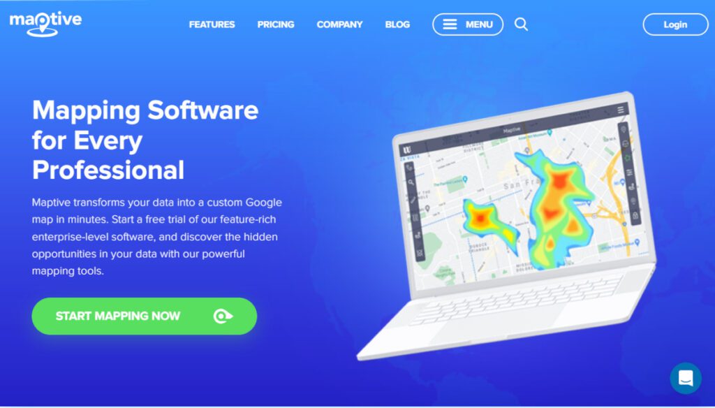
Maptive is a software for business data mapping. It’s a great option for real estate firms, sales teams, healthcare businesses, transport and supply chain operations, plus more. Maptive offers a robust feature set that can support your team in analyzing spatial data, using predictive analytics to make business decisions, plus more.
Maptive offers tools that can help any type of business, including drive time maps, heat maps, territory mapping tools, demographics, geographic boundary mapping, and data grouping, plus full customization of visualizations. Maptive will also soon launch CRM integrations so that you can connect the platform to your existing CRM.
Maptive Features:
– Intuitive Design
Maptive proves that GIS mapping software doesn’t have to be complicated. The powerful map tools do the analysis for you, so no coding is required. Maptive is a cloud and web-based solution, so there are no downloads required, you always have the most updated features, and you can access it from any device desktop, tablet, or mobile. Quickly and easily make a map from your location data by uploading a spreadsheet.
– Powerful Map Tools
Find hidden opportunities in your data with a powerful map analysis tools that do the heavy lifting for you. It’s not called an easy to use map maker for nothing: optimize routes, create heat maps, and plot up to 100,000 locations in a matter of clicks.
– Wide Range of Customizations
The custom map maker has countless options to personalize your map and create beautiful data visualizations for internal analysis, presentations, websites, or public sharing: Upload branded images for map markers (or use one of the 20+ dynamically customizable built-in options). Customize marker size, colors, and styles. Choose a default starting zoom level and map position. Customize and personalize your base map style.
– Share, Print, Embed, Display
Choose how to display and share your location map: share it privately with teammates, publish it publicly to the web, embed your interactive map on a website, or export the map image to print or insert into documents.
– Google Maps Reliability
Maptive is powered by Google’s best-in-class enterprise-level mapping technology so the customers can expect global coverage, world-class tools, and unmatched performance.
– Enterprise Level Security and Support
This platform was built from the ground up with security in mind. Powerful encryption, fully redundant backup and recovery systems, two-factor authentication, full permission level control, password requirements & Cloudflare endpoint protection are just some of the security features built in. For everything else, The support team is always available to help.
8. CleverMaps
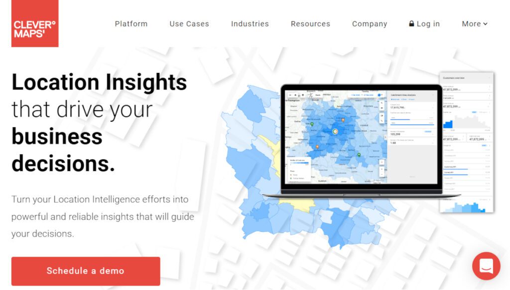
CleverMaps is a Location Intelligence Platform supporting the Modern Data Stack ecosystem and a provider of data science services connected to Location Analytics. Their solutions provide insights to support strategic decisions about any location related questions.
CleverMaps (formerly CleverAnalytics) was founded in 2015 and since then has successfully delivered more than 100 projects across 20 countries in many industries including Retail, Insurance, Banking, Real-Estate, delivery Services and more.
CleverMaps is a map-based analytics platform transforming how the world is using data to solve location-related problems. CleverMaps empowers people and organizations to make data-driven decisions based on the insights visualized in the intuitive and interactive analytical map.
This platform allows you to integrate data from multiple sources of any scale, analyze it in the integrated computation engine, visualize the results and get your answers.
The analytical outcomes can be exported directly to a file, embedded in your application or shared by a link with your colleagues.
– The logical data model for spatial data
The logical multidimensional data model is the heart of the platform.
It works on the same logic as you are used to from standard Business Intelligence tools, but the CleverMaps one can handle spatial data of any scale.
The data model establishes relations between datasets, the location context, and the composed metrics, which allow you to perform real-time location analysis.
The main benefit is that the data model represents the definitions and properties of data elements that stay the same with any data updates or technology changes.
– Metrics and indicators builder
CleverMaps provides a mathematical engine that allows you to define metrics for your location analysis. Metrics enable you to easily slice and dice the data from any critical perspective for your business and visualize it on a map.
CleverMaps gives you the ability to define the metric once and use it repeatedly in a different context with no SQL. Or combine multiple metrics together for advanced spatial analytics. You can either use the metrics cheatsheet or create a custom one.
-Native spatial queries
The spatial query is a query in a spatial database that is answered based on geometric information, for example, how many people live within specific proximity from a store.
CleverMaps has native spatial queries that allow analyzing walking, driving, biking distance, or a custom perimeter from any location on the map. All it takes is a click to the map or searching for the location through the search field. No coding, no SQL, no changes to the database.
9. GapMaps
GapMaps is a Cloud based GIS Mapping and location intelligence platform, it gives companies valuable demographic, economic & social data needed to make informed decisions with location intelligence analysis.
The costs of making the wrong decision are huge, it’s why the world’s most successful companies choose this platform. In one simple platform, GapMaps reveals the most invaluable location intel.
The real-time inputs and insights help you quickly understand where your competitors, locations, and customers are. Leading you to the right place for all the right reasons.
Seize the opportunity, GapMaps holds the latest and most valuable demographic, economic, and social intel, providing the path to the right decisions.
– See the Facts
Park the gut feel for a moment and look at the data that matters. You’ll find ours accessible and invaluable.
– Hold the Knowledge
GapMaps’ unrivalled experience and understanding provides the most comprehensive analysis in the market.
– Secure the Future
When the biggest decisions are based on the most relevant facts and insights, you can make them with confidence.
If you’re looking for one simple, easy-to-use location intelligence platform, you need GapMaps Live:
– Simple to use. You’ll be up and running in no time
GapMaps Live is available in the cloud where it’s easy to set up and use. You don’t need sophisticated mapping skills to get started. It’s simple to learn and pays big dividends.
– Find new customers fast. Know where your customers are in your catchments
Use GapMaps Live’s powerful insights to visualise all the latest location intel down to the smallest level data blocks. Finding new customers has never been so easy.
– Know thy enemy. Analyse your competition in granular detail
Understand your competitive landscape. GapMaps Live lets you visualise all competitor and reference brand locations across multiple industry sectors. Act with powerful knowledge at your fingertips and beat the competition hands down.
– Increase your sales. Discover untapped catchment areas
GapMaps Live gives you tremendous flexibility in creating catchments based on visitation patterns to validate your business case. Visualise customer travel patterns to and from a location and understand how long they visit and when they visit to maximise your sales.
10. Geoblink
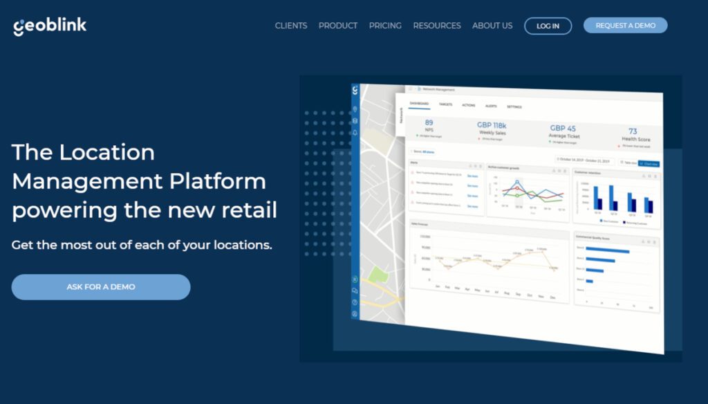
Geoblink‘s Location Management Platform was designed to help professionals with different business profiles achieve their goals and make their locations reach their full potential. The Location Management platform powering the new retail, get the most out of each of your locations.
The future of retail is about having full control of each location, no point of sale or commercial asset is the same—and they shouldn’t be treated as such. Geoblink gives you a 360º view of what impacts site performance.
How does Geoblink help you get the most out of your locations? Gain strategic insights about your business instantly and roll out tailored action plans to maximise success:
– Seamless data integration
Geoblink helps you centralise your tools and business data so you can and visualise and monitor performance in one place.
– More data for more context
Your data is then enriched with Geoblink’s premium location data to give you the full context on what is happening around your sites.
– Operable insights
Your team will be automatically notified about problems and opportunities across your network to apply the right measures.
– Strategic plan roll-out
Tailor your action plan by site, involve the right people to execute it, revamp your product mix or relocate to the right location.
Why choose Geoblink to help maximise your locations’ performance? That’s why:
– Make sense out of data
Easily unify and visualise your point of sale data and third-party data in one place.
– Actionable intelligence
Get immediate insights and take the proper measures to ensure success per location.
– Full network control
Obtain a 360º view of your locations and monitor their performance.
– Unique location data insights
Monitor how spending, footfall, competitor movements, etc. affect your network.
– Automatic performance alerts
Flag potential issues before they become problems and proactively solve them.
– Growth potential identification
Capitalise on growth potential across your entire network, from catchment area to territory level.
Conclusion
The list above has the best location intelligence software to consider when you need location-based insights for your business. The main difference between these solutions is the features they provide.
And the best intelligence software for location data that fits your organization is the one that covers all the features and functionality you need.


